Until 1947 this car-park had been a low grass-covered hill for at least a thousand years, a low hill that was then dug out and flattened except for the peak in front of you to give you an idea of its original height.
When the local Pictish people here at the northern end of their kingdom of Fortriu erected one of their mysterious (to us, not them!) symbol stones, it may have been this hillock in the marshes around that they chose for its message told by crescents with broken arrows and mirrors. It may have had even earlier uses to the ones who carved the half-dozen or so 'cup-marks'.
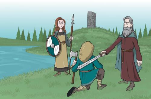
The Norse based in Orkney raided the mainland coasts, killing and stealing for hundreds of years. King Malcolm gave Caithness to the Orkney Earls and they operated there and in Sutherland and in the Western Isles—the Sudreys—and all the way down the coast to the Irish Sea. Earl Sigurd's men will have explored the Cromarty Firth and discovered people to fight or to work with to gather food and supplies. Sigurd the Stout was no pushover but he was killed in 1014 when the High King of Ireland Brian Boru brought the Viking forces to battle at Clontarf by Dublin.
His son Thorfinn, nicknamed 'The Mighty' built up his holdings in Orkney and further afield in the mainland and Western Isles. His sea battle with MacBeth of Duncansby Head was just an opener for another at Torfness, likely on or close to the turf/peat-covered Black Isle, where MacBeth had gathered forces from all over Scotland but was still beaten.
This gave Thorfinn unfettered access to Ross for colonisation and he made use of it. Free Norse would have settled up the Strathpeffer and Strathconon and on the hillsides around, and further. And a thread that joined his lands was the Thing (Norse Þing) system of regular assemblies of the free men and women.
The 11th-Century Christian Norse community of Ross would have been ruled by a Law Council, assembled as a court—the Þing—to establish laws and to settle disputes. The Dingwall Thing-site complex consisted of the church within its churchyard, the hill mound within its hillyard, and an open grassy field to the west. An archaeological survey in 2011 revealed the Hill mound to be at least partly fenced by a ditch following the curve of line of the present road.
When the time came, freemen from all over would have made their way to Dingwall, many making 'booths' for sleeping. There would have been races and competitions in horse-racing, athletics, feats of strength, wrestling. There would have been markets selling cloth, leatherwork, foodstuffs.
In the Christian era the Law Council would have assembled on the area reserved for worship. There the council members would have received blessings and spiritual authority from the priest in its convening as the Thing Court. From the church they would have progressed to the Thing Mound to exercise its authority over the gathered assembly. The Law-speaker was there to resolve disputes, Thorfinn may have been there to enforce his own authority and especially if he were seeking men for an expedition.
The Moot Hill Obelisk
The site continued to function as a focal point long after the Viking era ended, becoming known as the Moot Hill of Dingwall and used by Scottish monarchs to confer noble title on the heirs presumptive.
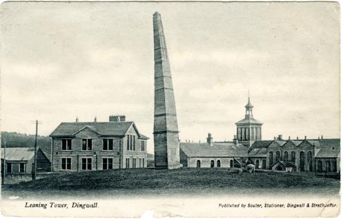
Eventually the ground was acquired by George Mackenzie, the first Earl of Cromartie. He erected the MacKenzie Monument on the mound, a 50-60 foot high obelisk nicknamed The Pyramid by local dwellers (from the pointed top), and the Earl was laid to his final rest beside it in 1714. An earthquake in 1816 knocked it a few degrees off vertical and it stood as 'Dingwall's Leaning Tower' for a century, until it was dismantled in 1917. The present replacement monument was erected in 1923 by Sibell, Countess of Cromartie. In 1947 the slope around the mound was levelled and leased to the Council and is still part of the Cromartie estate.
Further reading
D D MacDonald: Investigating Dingwall as Þingvöllr (2013)
Dr Oliver J T O’Grady: Cromartie Memorial Car Park Dingwall Archaeological Excavation (2012)
Olwyn Owen ed: Things in the Viking World (2012)
Dr Oliver J T O’Grady: St Clement’s Aisle, Dingwall Parish Church – Report on Geophysical Survey Electrical Resistance (Oct 2011)
The Orkneyinga saga
Panel sponsored by the Gough Trust
Do you know something we don't?
Please contact us if you spot an error here or on the panel, or if you have a suggestion for improving the information using »»» this form.

Once you have enjoyed your walk and learning more about Dingwall, you can donate between £1 and £20 by text towards the maintenance and development of the Heritage Trail.
Text DINGWALL to 70450 to give £3.
To donate any other value, add the digit/s: e.g. DINGWALL5 gives £5, DINGWALL12, £12. We, along with over 5500 charities across the UK, trust DONR to collect donations securely.